filmov
tv
How to create an interactive map in Microsoft SharePoint lists

Показать описание
In this video, you'll learn how to take advantage by List View Column formatting in order to create an interactive map.
🔗 Interactive Europe map sample
Open a list in SharePoint using query string parameters:
?FocusModeOff=1&sw=bypass
👇
👆
📺 REQUEST VIDEOS THAT YOU'D LIKE TO SEE
🎬More Videos:
📺My YouTube Channel:
🔗Let’s connect on social:
⏲Timestamps
00:00 Introduction
00:34 Geographic Map Demo
01:27 SharePoint Lists are opened in Microsoft Lists by default
02:11 How to change the behavior
03:53 Open a list in SharePoint using ?FocusModeOff=1&sw=bypass
05:05 Creating the interactive map from scratch
07:45 Where you can create Geographic Maps
09:03 How to get a single country in the SVG image
10:37 Creating a new list and applying the list view formatting
13:30 Embedding the list view in a SharePoint page
14:34 Conclusion
#GiulianoDeLuca #DeLuca
 0:04:20
How To Create an Interactive Video On YouTube (in 2024)
 0:10:12
How to Create an Interactive Presentation That Engages Your Audience
 0:01:19
Create an Interactive PDF with hover over pop ups in Adobe Illustrator and Acrobat
 0:08:47
How to Create Amazing Interactive Videos (Plus Top Interactive Video Platforms)
 0:06:57
Create Interactive Lesson Plans | Back to School
 0:11:56
How To Create an Interactive PDF Flipbook Ebook Step-by-Step
 0:01:05
How to Create an Interactive Online Course – Theory, Practice, and Expert Feedback
 0:21:34
Create Interactive Worksheets & Checklists With Canva For Free
 0:46:46
WebQuest as an educational interactive tool
 0:19:21
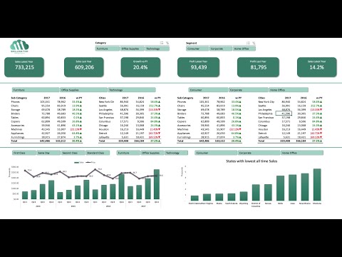
📊 How to Build Excel Interactive Dashboards
 0:37:40
Create an interactive magazine with sidebar menu in Adobe InDesign
 0:09:45
Create an Interactive PDF with Rollover Pop-ups
 0:00:30
Lesson Plan: Create an Interactive E-Book | Digital Publishing with Your Students
 0:07:36
Learn JavaScript in 7 minutes | Create Interactive Websites | Code in 5
 0:09:52
How to Create an Interactive Double Slider Card
 0:04:08
How to create interactive worksheets on LiveWorksheets
 0:14:55
Create an Interactive App Navigation Menu in Figma
 0:00:55
How to create interactive walkthroughs and in-app interactive guides
 0:16:09
How to Create an Interactive PDF Ebook with Clickable Tabs
 0:24:44
Create an interactive E-Magazine in Adobe InDesign
 0:40:32
Create interactive excel dashboard in 5 simple steps #exceldashboard #exceltutorial #pivottable
 0:01:46
How to Create an Interactive PDF | Flipsnack.com
 0:10:41
How to Create an Interactive Map with Visme
 0:18:42
How to create an INTERACTIVE GAME in POWERPOINT
Комментарии