filmov
tv
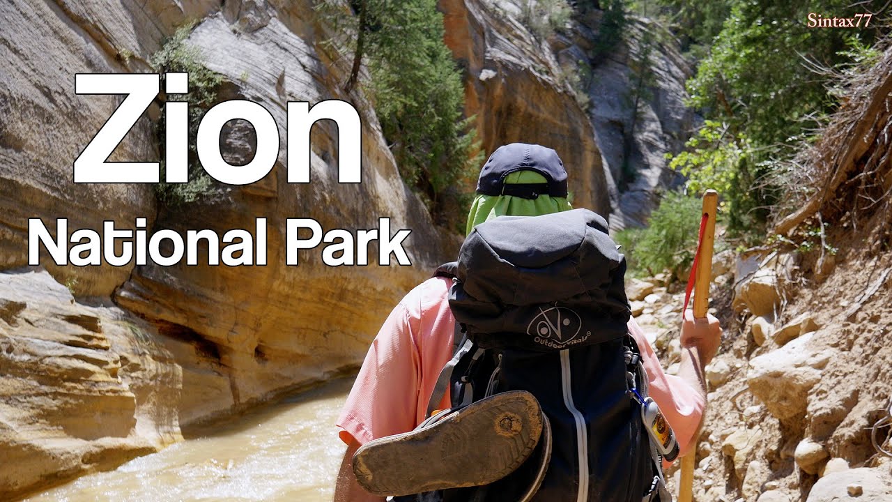
Zion National Park - Hiking, Camping & Backpacking
Показать описание
5 days of Hiking, Camping & Backpacking in Southern Utah’s Zion National Park.
We’ll be doing 3 different trips:
A West Rim Backpacking Trip
Exploring & hiking the Frontcountry Zion National Park area while car camping in Springdale, Utah.
Backcountry camping on a top-down Narrows hike, ending at the Zion visitor center back in Springdale.
Objective #1: Backcountry camp on Zion Canyon’s West Rim
Trailhead Used: West Rim Trailhead, Near Lava Point Overlook.
N37° 22.899′ W113° 01.370′
West Rim Itinerary, Day 1:
Park at the West Rim Trailhead near Lava Point.
This is a gravel lot with parking for a half dozen cars or so. It’s about a 40 minute drive from Springdale, Utah. The latter part of the drive is a dirt road, cars should be fine with a bit of care.
Head south on the West Rim Trail
Camp at West Rim campsite #4 N37° 17.144' W112° 59.030'
West Rim Hike-In Mileage: 8 miles
West Rim Hike-In Gross Elevation Gain: 1,073
West Rim Itinerary, Day 2:
Backtrack north on the West Rim Trail
Return to the trailhead lot near Lava Point.
Ghost town pit-stop in Grafton, Utah
Continue on to Springdale, Utah.
Have some tacos at the Whiptail Grill, right next door to the campground.
Objective #2: Explore Zion National Park’s Frontcountry & Springdale, Utah.
Zion Frontcountry / Springdale Itinerary. Day 1:
Take the free Zion bus, or a short walk north to the Zion National Park entrance.
Take the bus from the visitor center to Big Bend.
From the Big Bend bus stop, take the trail south along the Virgin River to Weeping Rock.
Road hike a bit along the Mount Carmel Highway.
Hop a bus back to the Zion Visitor Center.
Explore Springdale, eat some ice cream at the Zion Candy Company.
Objective #3: Hike and Backcountry Camp the Narrows, from the Top Down.
Trailhead: Chamberlain’s Ranch Trailhead (aka Zion Narrows Upper Trailhead)
N37° 23.121′ W112° 50.339′
Note: This was an end-to-end hike that required us to park a second vehicle at the Zion visitor center in Springdale to use as a shuttle back to the starting point.
Zion NP – The Narrows, Top-down Hike Itinerary, Day 1:
Park at the Narrows Upper Trailhead.
Head southwest on the trail, which is actually dirt road, for the first 3 miles.
Continue to follow the trail along the Virgin River, through the Narrows.
This trail is very easy to follow, as it is literally the river. A majority of the time is spent walking in the river bed in ankle deep to knee deep water depending on conditions, depending on current water-flow conditions.
Note for reference: The ccf reading during our trip was roughly 40 CCF. Anything under 50 ccf is considered ideal. Above 100 cfs, conditions can be difficult and hazardous. At 130 ccf, top-down narrows hikes will be closed. At 150 ccf, bottom up Narrows hikes will be closed. During a flash flood, flows can exceed 1000 cfs.
Setup camp at the Narrows campsite #12. N37° 19.982' W112° 57.373'
Narrows Day 1 Hiking Time: 7 Hours
Zion NP – The Narrows, Top-down Hike Itinerary, Day 2:
Break camp & continue south along the Virgin River.
Exit the trail & catch a bus at the Temple of Sinawava shuttle stop.
Return to the Zion Visitor Center
Drive to retrieve starting vehicle
Narrows Day 2 Hiking Time: 4 Hours
Notable Gear Seen:
Disclosure: This post & video contains affiliate links, which means I may receive a commission for purchases made through my links. Cross reference, do your own research and make your own decisions, duh ;)
 0:13:54
TOP 10 HIKES IN ZION NATIONAL PARK, UTAH
 0:08:36
The 8 Most Popular Hiking Trails in Zion National Park | Overview/Guide
 0:08:04
Top Things You NEED To Do In Zion National Park
 0:11:28
ZION NATIONAL PARK, UTAH | Best Things To Do In Zion + Travel Tips
 0:03:58
Angel's Landing - Scariest Hike in America? Steep Drop off - Zion National Park, Utah
 0:00:21
5 MUST DO HIKES In Zion & Bryce Canyon National Parks 😍 #zion #brycecanyon #utah #hiking
 0:04:34
Top 3 Trails in Zion National Park - HD Video
 0:35:00
The Narrows - Virtual Hike in the Zion National Park in 4K (Ultra HD) with Nature Sounds
 0:00:31
#zionnationalpark #utah #desert #canyon #zion #hiking #hikingadventures #nationalpark #park #trip
 0:04:10
Canyon Overlook Trail - A Great Beginner Hike in Zion National Park
 0:00:06
ONE DAY ZION ITINERARY!
 0:05:29
TOP 10 Things to do in Zion National Park (No Hiking Required!)
 0:08:14
How To Spend 72 Hours in Zion National Park, Utah
 0:56:47
Call of the Canyon: Zion National Park [FULL DOCUMENTARY]
 0:11:13
Zion 101 for First-Time Visitors
 0:08:52
Best Hikes in Zion National Park (All Experience Levels)
 0:00:05
Overcrowding at Angels Landing, Zion National Park, Utah
 0:09:35
How to Hike the Narrows Zion
 0:08:49
12 EPIC Hiking Trails in Zion National Park
 0:05:45
Investigation: Hikers pay deadly price on Zion's Angels Landing trail
 0:14:44
The ultimate cut-the crap guide to hiking Angels Landing | Zion National Park 4K HDR
 0:16:22
The TOP 10 Things to Do in Zion National Park | Best Hikes, Views, and Drives
 0:00:58
The Best Hikes in Zion National Park
 0:00:20
The Narrows: Zion National Park's Best Hike #hiking #nature #travel
Комментарии