filmov
tv
How to - Plot a route on OS maps and create a GPX file

Показать описание
Hey up youtubers this weeks video - How to - Plot a route on OS maps and create a GPX file
Title: How to Plot a Route on OS Maps and Create a GPX File for Off-Road Riding and MTB
Description:
Welcome to our guide on plotting your off-road riding and mountain biking routes using OS Maps and creating GPX files for your adventures! Whether you're a seasoned rider or just getting started, mastering route planning is essential for a successful and enjoyable journey.
In this tutorial, we'll walk you through the step-by-step process of plotting your route on OS Maps, a trusted resource for outdoor enthusiasts, and exporting it as a GPX file compatible with various GPS devices and applications.
Here's what you'll learn:
1. **Introduction to OS Maps:** Discover the features and benefits of using OS Maps for planning your off-road adventures. From detailed topographic information to terrain analysis, OS Maps provides valuable insights for riders of all levels.
2. **Navigating OS Maps:** Learn how to navigate the OS Maps platform efficiently. We'll cover searching for locations, zooming in and out, and customizing map layers to suit your preferences.
3. **Plotting Your Route:** Follow along as we demonstrate the process of plotting your route on OS Maps. From selecting starting points to adding waypoints and highlighting key landmarks, we'll show you how to create a personalized route tailored to your riding preferences.
4. **Fine-Tuning Your Route:** Discover advanced tips for fine-tuning your route for optimal riding experience. We'll explore adjusting waypoints, avoiding obstacles, and optimizing elevation changes to ensure a smooth and enjoyable journey.
5. **Exporting as a GPX File:** Once your route is finalized, learn how to export it as a GPX file. A GPX file is a universal format supported by most GPS devices and navigation apps, allowing you to seamlessly transfer your route to your preferred device or application.
By the end of this tutorial, you'll have the knowledge and skills to plot your off-road riding and mountain biking routes with precision and confidence. Get ready to explore new trails, conquer challenging terrain, and embark on unforgettable adventures!
Subscribe to our channel for more tips, tutorials, and adventures in the world of outdoor exploration. Happy riding!
#OffRoadRiding #MountainBiking #RoutePlanning #OSMaps #GPXFiles #outdooradventure
Support this channel buy me a coffee ☕ thanks
ALWAYS FOLLOW THE GREEN LANE CODE !!
Easiest free ways to support my channel
1. Subscribe 😎
2. Like or Dislike 👍👎
3. Comment ✍
4. Hit the notification bell 🔔
5. Share my vids with your mates
Stay Safe, RIDE SAFE
Follow me -
Equipment -
GoPro Hero 10
Insta 360 one X2
Gopro hero 7 black
Akaso V50
Rode video micro, microphone
Synco Wireless Mic
Fimora 11
My current motorcycles are -
BMW GS1200 LC
Yamaha RD350 LC
Suzuki TS125ER
Honda C50
Suzuki Gp125
Scorpa 250 twenty
Suzuki TS125X
Ducati Hypermotard 1100 S
KTM 350 EXC-F
Husqvarna Vitpilen 701
 0:13:23
HOW I PLOTTED A BOOK IN 1 DAY // *detailed* plotting process and secret novel tips!
 0:09:38
The ONLY Way to Plot a Novel (It's Easier Than You Think!)
 0:14:51
How to Plot Your Novel FAST | Writing Advice
 0:13:47
How to: Plot a Function in Python
 0:12:51
'How do I come up with a plot for my novel?' | #AskAbbie
 0:21:27
How to Plot a Comic From Start to Finish!
 0:09:21
THIS PLOTTING TIP CHANGED MY LIFE: HOW TO PLOT YOUR BOOK EASY! 📖 my secret novel tip and template
 0:09:58
The Secret to a Well Paced Plot (and it's ridiculously easy) | Writing Tips
 0:00:38
Errorbar Charts In Python | Python Tutorial
 0:06:11
How to Plot a Graph on Word
 0:06:00
How to Plot a Novel
 0:05:42
How to Plot Points a Coordinate Plane | Positive and Negative Coordinates | Math with Mr. J
 0:08:09
HOW TO PLOT SHIPS POSITION ON A CHART USING LATITUDE AND LONGITUDE
 0:06:51
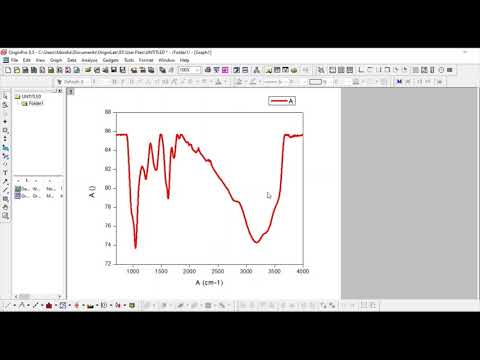
How to plot graphs in Origin Pro for Journal Paper Publication
 0:06:45
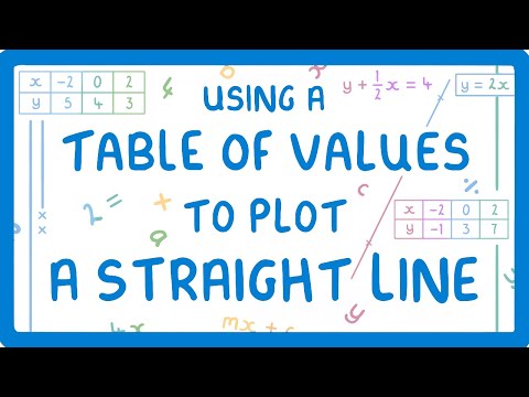
GCSE Maths - How to Plot a Straight Line Using a Table of Coordinates #70
 0:10:37
How to Plot a Course to Steer
 0:02:50
How to Plot a Line Graph - Pretty Straightforward
 0:05:28
GCSE Maths - How Do You Plot A Quadratic Curve? #77
 0:06:59
How to Plot 8 Digit Grid Coordinates
 0:02:09
How to Plot on Graph Paper : Easy-to-Intermediate Math
 0:09:19
HOW TO PLOT LOT PLAN
 0:09:19
How to Build an External Plot
 0:10:25
How to Plot a Graph on Paper in Science
 0:09:13
How to Plot a Thrilling Crime Novel
Комментарии